Showing posts with label kerry. Show all posts

Thursday, January 28, 2016

Cashelkeelty Stone Circles & Stone Row.


Getting to this site requires a good bit of effort and quite a bit of spare time.
For making the trip you will be rewarded with two stone circle's, a stone alignment and superb striking scenery surrounding you.

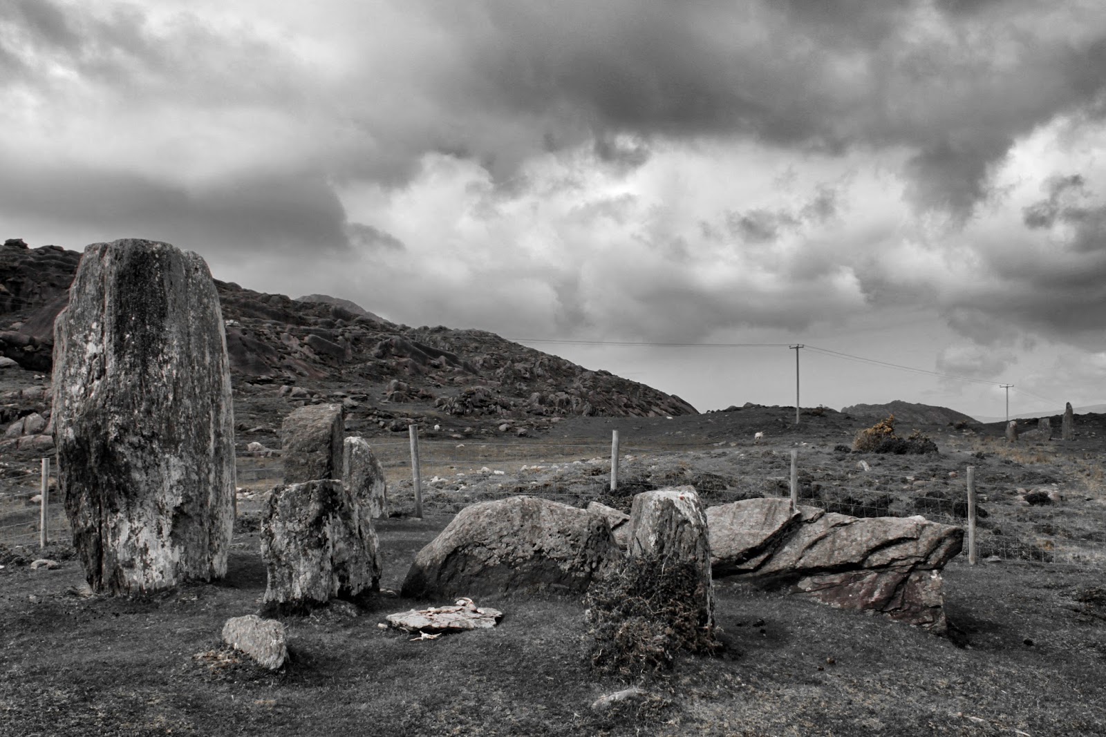
Cashelkeelty South East  (images 1-3)
The first part of this site was a five stone, stone circle (only three still stand).
With the two portal stones missing the axial stone is the biggest of the three - 1.5 meters in length and 0.5m in height.
The two side stones are slightly taller than the axial stone at 0.7m but shorter in length at 0.8m.
The diameter of the circle is close to 2 meters.
This site was excavated in the 1970's.

Beside this circle is a three stone row over 6 meters in length  (images 2-3).
It is thought that this alignment may have had four stones originally. 
The tallest of the stones is close to 3 meters in height.

Cashelkeelty North West  (images 4-6)
This circle is said to have had twelve stones originally but only three remain standing, with a fourth fallen very close to the standing ones.
The tallest of the three stones is close to 2.5 meters in height. 

Access - As mentioned getting to these sites will take a bit of time, parking can be found just off the R571 (after you pass through Lauragh). The site is signposted on the main road.
Climbing over a small stile the walk will bring you up through a forest via a nice waterfall.
Reaching the top of the trees you will climb over another stile and turn right (again signposted).
This starts another climb along a good pathway but a steep one (this part of the walk forms part of the stunning Beara way.
After a climb that seems to be not ending any time soon the South East circle comes into view with the North West circle just a bit further on.   


Friday, August 7, 2015

Gurteen Stone Circle


The superb but badly overgrown circle of Gurteen is even allowing for its present state a must see.

Eleven of the original twelve stones still stand.
This Circle also has a boulder burial stone as its centre piece.
The circle is just over 10 meters in diameter.
The stones in the circle vary in height from over 1 meter to just over 2.5 meters.

The location of this site really makes it special with scenic views all round and during my visit total silence.

Access The Circle is quite easy to find compared to other sites close by.
Park at the cattle gate (climb over) and walk up around the corner the circle will be on your Left.

Beware if visiting after rain as the ground around the site gets very bogey and cattle sometimes graze close by.


Monday, May 18, 2015

Clogherane Stone Row


Clogherane Stone Row really could not be in a better setting.
The two stones are situated on a flat rise over looking the bay of Kenmare with striking mountains/hills acting as a backdrop.

The stone row is aligned NNE - SSW.
The larger of the two stones is 2.6 meters in height and 1.5 meters in width at it's widest point.
The smaller stone is over 1 meter in height and just over 0.5 of a meter in width.

This site (and many others that I hope to be posting in the future) I came across as a result of Michael Mitchell's superb Blog  Walking to the stones.From Dartmoor to County Cork  .

Access - The stones are in a field that would appear to have sheep as company the majority of the time.
If you park in front of the house, on the right hand side the lane way will bring you to the stones behind the house.
Make sure not to block the lane way.    


Wednesday, October 15, 2014

Loher Stone Fort


Loher Stone Fort unlike the nearby Staigue Stone Fort is in fact an early Christian defended farmstead.
What you see today is the result of a recent reconstruction that when being carried out found the remains of farm buildings made of wood and later of stone.

In the interior circular house a souterrian entrance was found. This would have been used to hide when under attack and as a place for cool storage of foods.
The souterrian has been closed up since the restoration.

The walls are close to 3 meters in height and can be climbed from the interior via crossed stairways.
Unlike Staigue walking on top of the wall's is not a problem (once you have the head for height's).

Access - Loher is just a short drive from the N70 and is well signposted.
Parking is available for six or seven cars, unless someone goes sideways !
From there you are left with a short walk to the immaculately kept ground around and inside Loher.     
The views from Loher are nothing short of superb.
Mountains surround Loher on three sides with the fourth side giving you a great view of Ballinskelligs Bay where on a clear day you can see Skellig Michael in the distance.


Thursday, August 28, 2014

Eightercua Stone Row


Eightercua is without doubt my favourite stone row in Ireland.
Ireland may have bigger stone rows with more standing stones in them but the buzz that I have got both times when coming around the final bend on the N70 and seeing Eightercua is like spotting four really good friends that have been waiting for you.

This was a revisit to this site as when I first saw Eightercua it was a pretty dire day weather wise.
This visit was only a partial success as the site was undergoing what looked to be a pretty extensive dig that as you can see from the images it has come right up to the stones.

The stone row is about 7.5 meters in length.
The tallest of the stones is close to 3 meters in height with the smallest of the stones just over 2 meters in height.

At the base of the stones is what looks like a wall which has led some to think that the stones were part of a large chamber.
The enclosure that comes out from the stones is very visible and is about 15 meters in diameter.

Access - Eightercua can be seen from both ways on the N70. Parking is a problem as the lane ways around the site are very narrow and most of the property's close by are lived in.
So be careful you don't block someone in.   


Saturday, August 16, 2014

Staigue Stone Fort


Staigue Stone Fort is another of County Kerry's historical gems.
The fort can be found just off the main Sneem Waterville road, about 8 kilometres from Sneem.

The Stone Fort sits between rugged hills, with the view to the south opening up to Kenmare bay.

The forts walls are 5.5 meters in height and 4 meters thick at the base.
The diameter of the interior is over 27 meters. The inside has two small oval chambers 2 meters in height.
The entrance is under 2 meters in height, the passage is roofed with large double lintels.

The walls can be climbed via a series of crossed steps, you are asked not to walk along the top of the fort (but this seemed to be ignored by the majority on my visit).

The exact dating of the fort is unknown. It is thought to have been built pre St Patrick.
Doctor Peter Harbison ( never leave home without his "Guide to National and Historic Monuments of Ireland") suggests it may even date as far back as the first Century.

Access - The fort is well signposted from the main road, parking is available for several cars. 


Thursday, July 24, 2014

Ross Castle


Ross Castle must be the most photographed castle in Ireland as on the morning of my visit there had to be upwards of two hundred people all milling about and all seemed to have cameras. Extreme patience was required to get the above shots.

The castle is considered to be a typical example of the type of stronghold of an Irish Chieftain during the Middle Ages.
Probably built in the late 15th century by one of the O'Donoghue Ross chieftains.
The castle is better known for its association with the Browne's of Killarney who owned the castle most recently.

The four storey square keep is built on a rocky outcrop on Ross Island by the shore of Lough Leane.
The castle is surrounded by a square defensive wall with two of the four original corner towers surviving today.

Ross Castle is said to be the last stronghold in Munster to hold out against Cromwell.
It was eventually taken by General Ludlow in 1652 - when it was fired upon from the lake.

The castle has been much altered in the intervening years.
It came into state care in the 70s and was restored by the OPW.
Allowing for the major restoration of the castle it still has plenty of its original character.

Access -  the castle is only a couple of minutes drive from Killarney town.
Parking is not a problem.
The inside of the castle can be viewed as part of a guided tour. 


Friday, May 16, 2014

Parkavonear Castle


Located only a short drive from Killarney town you can find the ruin of Parkavonear Norman Castle.

The Castle is very unusual in that it is round unlike the majority of Norman castles of that time which tended to be rectangular.
Originally the castle would have had a mote around it with the doorway higher that the later one that you can see today
The castle is dated  13th Century and is one of many that came to be built following the 1169 invasion of Ireland by Anglo-Norman forces.

What remains today is pretty basic.
The wall's are 2 meters thick with the interior about 9 meters in diameter.
The castle is two storeys high with a stairway built into the wall of the ruin.
The first storey still has the remains of a fireplace.

Access - The castle is right beside the lower part of Aghadoe Church & Round Tower graveyard.
The lane way that brings you down to the castle is narrow (it runs alongside the lower part of the graveyard)
so park up at the church and walk down to the ruin.

The castle can be found in it's own neat enclosure, the setting for this unique ruin could not be better with one of Killarney's lakes acting as a backdrop.       


Tuesday, February 11, 2014

Graigue Standing Stone


To be honest I was on my way to another site when I came across Graigue.
Having seen images of this standing stone I had always thought the site was far from the beaten track.    

This giant of a stone has split into two.
The larger of the slabs remains upright with the smaller one now at a forty five degree angle (resting on two large stones).
The upright stone is over 3.5 meters in height and over 2.5 meters in width.
The smaller slab is 3 meters in height and over 2 meters in width.

Access - The stone can be seen very clearly from the road, it is in a field just before you reach the quarry. Parking will be a problem as the road is very narrow, to get up close to the stone you will have to climb a bank (small) and hop over a fence.


Tuesday, February 4, 2014

Ballycarbery Castle


The stunning ruin of Ballycarbery Castle can be found a short drive from Cahersiveen Co Kerry.
The castle is dated from the 16th Century but is built on an earlier site thought to date from the 14th Century.

The castle was originally the seat of the MacCarthy Mor family.
Sources indicate that in the early 16th Century it was occupied by the O'Connells in their capacity as MacCarthy wardens.
From then the castle was passed onto Sir Valentine Browne following the death of its owner Daniel McCarthy Mor.

The majority of the castle wall were destroyed by Cromwell's forces in 1652 when it was fired on with cannons.

What you can see today gives you an idea of what a fantastic site Ballycarbery was when intact.


It would seem that this part of history has been forgotten as the ruin is in quite a bad state and in need of restoration.

Access - Parking can be found for a few cars quite close to the ruin.
The field the castle is in can sometimes have cattle in it so you will have to duck under a wire fence to get up close.

If you have time, you will find close by Cahergal Stone Fort  which is well worth checking out ! 


Thursday, October 31, 2013

Dromatouk Standing Stones


Located a very short distance from  Dromatouk Stone Circle  you can find Dromatouk Standing Stones.
There are three stones with the centre stone being the real eye catcher of the set.
The middle stone (rectangle in shape) is just under 2.5 meters in height and has an ogham inscription on its side.
The stones either side are much smaller with the one on the side of the circle looking like it has been moved at some stage.

To find the standing stones you follow the same route as the circle.
The stones are very visible on your right.
I have read in some posts that the field that contains the standing stones sometimes has cattle in it.
Like the circle, the time of the year (and weather) when you visit this site will probably determine how difficult your trek will be.  

Thursday, August 29, 2013

Ardamore Stone Alignment & Standing Stone


Ardamore stone alignment consists of three standing stones, which is over 7 meters in length.
The tallest of the three is 3 meters in height with the other two just over 2 meters.
The alignment is claimed to be orientated on the setting sun at the Winter Solstice.  
The setting for this site could not be more stunning with great backdrops in every direction (on a clear day).

The standing stone is in the same field as the alignment and is equally impressive.
This beast of a stone is north-east of the alignment and is located in the bottom part of the field.
The stone is close to 3 meters in height and is 2 meters in width.
One side of the stone is decorated with art motifs, to see these markings click on this link to Megalithic Ireland .
Finding this great site is pretty easy I asked for permission at the farm and walked up the rough road (about 4 minutes).   


Thursday, August 22, 2013

Dromatouk Stone Circle


Dromatouk Stone Circle is a great little circle that is well worth the effort of finding.
When you do find the circle it throws in a nice bonus for the effort (see below).

The small (but perfectly proportioned) circle has five stones - with two large black thorn trees growing inside the stones.
The largest of the stone is 1.5 meters in height with the circle over 2 meters in diameter.

Finding the circle is pretty easy if you approach it from the southern side.
I found a track that brought me right up to the field that has the circle in it.
I made my trek to the circle in the middle of Ireland's two week heatwave (yes heatwave and Ireland in the same sentence!!!!), which meant the track was dry and firm. This could be a different story at other times of the year as the land is very boggy in most parts.

The bonus you can just spot in the top image.
It is behind the trees to the right of the circle - Standing stones (a post of which will follow soon).