Tuesday, December 6, 2016

Srah Castle


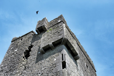
The striking but dangerous ruin of Srah Castle can be found a short walk from Tullamore town along the Grand Canal.

Built in 1588 by John Briscoe (an Elizabethan officer from Cumberland).

The four storey tower is 20 meters high and has the ruin of a 17th Century house attached on the NW corner.

Some of the features of this ruin are a Bartizan, gun loops and a Machicolation (which was used for dropping rocks and boiling liquids on attackers of the castle) Image 6 shows these features.

Despite being well fortified the castle was badly damaged in 1650 in the Cromwell campaigns.

The inside of the ruin has a broken spiral staircase (image 3) this may have been broken recently on safety grounds.

Access - The castle can be spotted as you walk along the canal, an easy enough fence to climb brings you into the field where the ruin is.


Thursday, October 20, 2016

Kilmaclenine Wedge Tomb


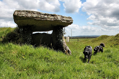
The beautifully preserved tomb of Kilmaclenine can be found in its own somewhat bumpy enclosure.

The fact that the tomb sits surrounded by these mini hills has probably helped preserve and protect this fine site.

The tomb has a giant capstone which is 2 meters in width 3 meters in length and is 0.3 meters in thickness.
The two large side stones and the back stone are 1.5 meters in height, it is possible to stand inside the tomb for someone under 1.8 meters.

Access -
The tomb can be found up a lane way just beside a modern bungalow,  parking is available beside the site. On the day of my visit I had the pleasure of two chatty dogs who were very keen to pose beside the tomb.


Thursday, September 15, 2016

Antrim Round Tower


Antrim Round Tower is an impressive 28 metre tall tower that is dated around the 10th Century.     
The tower is known locally as The Steeple. 
The doorway is over 2 meters from ground level.
Above the doorway features a carving of a Celtic cross (image 3).

The site is all that remains of a monastic settlement which dates as far back as 495 AD and is said to have been founded by St Aeibh. 

The Annals of the Four Masters report that the site was destroyed in 1018 and burned in 1147.

The area was landscaped during the 19th century and parts of the settlement were demolished and cleared away.

The  surrounding area was turned into a private Demise and repairs were carried out on the tower at this time.

A large boulder is known as the Witch's Stone, it has two bullauns and lies approximately 6 meters from the tower

Access  - The tower is located in parkland that can be accessed from Steeple Road.


Thursday, August 4, 2016

Claregalway Friary


The vast ruin of Clairegalway Friary stands overlooking the river Claire as you leave the village of Clairegalway travelling north on the N17.

The Friary dates back to the 13th Century and was built by John de Cogan.
The Franciscan community lived under the patronage of the de Cogan clan until 1327, when
de Cogan gave them the building and surrounding lands.

The following years saw the friary flourish in numbers and wealth.

The ruined state of the friary is mostly a result of two major happenings in the 16th Century.
In 1538 Henry VIII sent Lord Leonard Gray to Galway.
It is recorded that the friary at Claregalway was rifled by Gray’s troops on their way to Galway.
In 1589 Sir Richard Bingham, the English governor of Connaught,  cleared the friary and used the building as a barracks.

By 1641 the Franciscans had returned to the friary.
A failed attempt was made to rebuild.
From then on their numbers declined so that by 1838 the friary was down to two members.    

In 1892 Lord Clanmorris donated the property to the Commissioner of Public Works

The Franciscan friary consists of a nave,choir, north aisle and transept. 
The square bell tower is the most striking feature of the friary and is dated to the 15th Century.
It is 24 meters in height.
All other parts that survive today of the structure were built in phases during the friary's time of prosperity.

Access - The friary can be spotted from the main road (on your left) as you leave Claregalway heading north on the N17.
Parking can be found in the car park which is right beside the graveyard and ruin. 


Friday, May 27, 2016

Castletown Stone Row / Alignment


The stone row of Castletown (also known as Craig Stone Row)  is just one of those alignments that  looks good from a distance and even better close up.

The alignment is just over 5 meters in length, with the distance between the stones close to 2.5 meters.

The tallest of the stones is 1.6 meters in height the middle stone is 1.1 meters tall with the other end stone being 1.4 meters in height.

Access - The site is a short drive from the N20.
The field is very large and the stones can be seen from the road.
The field the alignment is in can sometimes have cattle grazing.
The farmer who's land it is on seemed happy enough  for me to get up close to the site once the cattle were not present. 


Tuesday, May 10, 2016

Cloughanover Castle


The history of Cloughanover Castle is pretty much a mystery.
The couple of scraps of information I have found are below.


What is known is that the castle was built as a stronghold by the Anglo-Norman de Burgo family in 1450.

It is claimed that Cloughanover Castle was destroyed by Cromwellian forces in the 17th century.

Not very much remains today, but the fireplace and entrance to the castle latrines/toilets can be seen clearly in (image 3).

Access - The ruin is visable on the right coming from Galway heading towards Headford on the N84.
Take a right turn before the petrol station.  This will bring you to Cambells Tavern in Cloughanover
Cloughanover Castle is just across a couple of fields from Cambells Tavern.


Friday, April 22, 2016

Cloyne Round Tower


The site at Cloynes dates back to the 6th Century when a monastery was founded by
St Colman Mac Lenine.

The tower which is said to be 10th Century is composed of a dark purplish sandstone and rises to a height of just over 30 meters.
The doorway is close to 3.5 meters from the base, which is built on a offset but this was not visible on my visit (image 4). 
The tower has a total of 9 windows 7 of which are lintelled, the windows on the 3rd and 5th floor are both angled.

The tower was struck by lightning in 1749 but the cap was gone by then and the battlements you see today were in place.

In recent years it was possible to climb to the top of the tower, but this is no longer allowed due to maintenance and insurance issues.   

Access -
Travelling on the N25 Cork to Midleton road you will see a turn for Cloyne R629, this bring you directly onto the appropriately named Church St.

The tower is opposite St Colman's Church of Ireland Cathedral.
Parking can be found close to the tower quite easy.   


Tuesday, March 22, 2016

Coulagh Stone Circle


The Stone Circle of Coulagh is being kind to the site a bit of a mess.
Only two stone remain standing (both leaning quite strongly).

Because of the other stones in close proximity it is pretty hard to picture the circle in it's original form.
Is it a five stone recumbent circle or maybe the circle was even bigger, could the two standing stones be portal stones to the original circle.

I wish that I could give you a better idea of this site but probably we are best going with Jack Roberts who is pretty sure the site is a true 5 stone circle.

The site is worth a visit, but the area has many other stunning sites to offer like Ardgroom.

Access -  The R575 will bring you to the turn off for the site, the lane way is very narrow and the stones will be on your left two or so fields up. 


Thursday, February 25, 2016

Carrigadrohid Castle


This very striking ruin is built on a rocky outcrop and has the river Lee flowing by.

Carrigadrohid is said (disputed by some) to have been built in the 15th century by the MacCarthys of Muskerry.

The castle is a three story tower.
It has a second story entrance via the bridge on the eastern wall of the ruin.

The Castle was besieged by Parliamentary forces in 1650.
Bishop MacEgan (Bishop of Ross) who had been captured by Cromwell's General was promised his freedom if he could persuade the garrison of Carrigadrohid Castle to surrender.
The Bishop is said to have urged the garrison to fight till the end, and told the men "to hold out to the last for religion and Country".
The Bishop was hanged from a nearby tree with the reigns of his own horse in view of the castle.

Carrigadrohid later passed into the ownership of the Bowen family who occupied it until it was abandoned in the mid 18th Century.

Access - Parking can be found close to the castle and if the weather is nicer than on my visit there is a picnic area right beside the river bank.


Thursday, January 28, 2016

Cashelkeelty Stone Circles & Stone Row.


Getting to this site requires a good bit of effort and quite a bit of spare time.
For making the trip you will be rewarded with two stone circle's, a stone alignment and superb striking scenery surrounding you.

Cashelkeelty South East  (images 1-3)
The first part of this site was a five stone, stone circle (only three still stand).
With the two portal stones missing the axial stone is the biggest of the three - 1.5 meters in length and 0.5m in height.
The two side stones are slightly taller than the axial stone at 0.7m but shorter in length at 0.8m.
The diameter of the circle is close to 2 meters.
This site was excavated in the 1970's.

Beside this circle is a three stone row over 6 meters in length  (images 2-3).
It is thought that this alignment may have had four stones originally. 
The tallest of the stones is close to 3 meters in height.

Cashelkeelty North West  (images 4-6)
This circle is said to have had twelve stones originally but only three remain standing, with a fourth fallen very close to the standing ones.
The tallest of the three stones is close to 2.5 meters in height. 

Access - As mentioned getting to these sites will take a bit of time, parking can be found just off the R571 (after you pass through Lauragh). The site is signposted on the main road.
Climbing over a small stile the walk will bring you up through a forest via a nice waterfall.
Reaching the top of the trees you will climb over another stile and turn right (again signposted).
This starts another climb along a good pathway but a steep one (this part of the walk forms part of the stunning Beara way.
After a climb that seems to be not ending any time soon the South East circle comes into view with the North West circle just a bit further on.